Geoscience Objects
geological-sections
The geological-sections schema is used to store geology as a set of planar cross sections. Soil layers and volumes are represented using 2D line segments on the section plane. This object does not support curved or crooked sections. Only geology and its associated properties are expected in a geological-sections object.
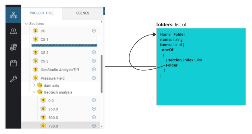
folders array
A recursive list of folders containing indices into the sections list. The folders give organizational structure to the set of cross sections stored in this object.
E.g.

sections array
A list of planar cross sections. Each cross section contains a set of volumes and surfaces.
-
name- Section name. -
description- Optional field for adding additional description about this object. -
origin- The coordinates of the section origin. [x, y, z]. -
RotationSection Rotation in model space.
volumes array
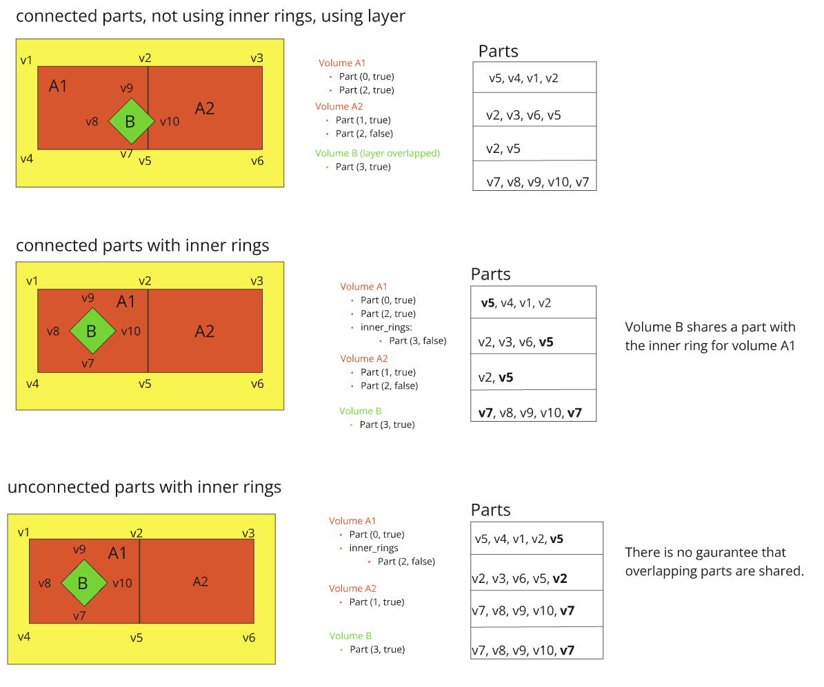
A list of polygon volumes. Each volume consists of one or more connected polyline parts which together represent a closed polygon (a ring). Holes in a volume can optionally be represented using a set of internal rings, where each ring is a non-intersected hole in the volume. Holes can also be represented using an overlapping volume in a different layer.
-
name: Volume name -
description: Optional additional description. -
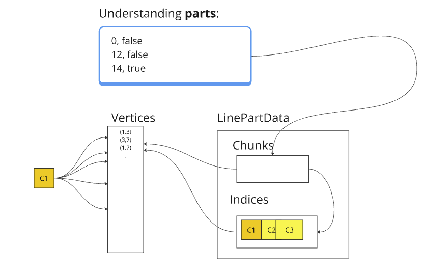
parts: Array of polyline parts. The entire array of parts creates a closed polygon. Each entry is a pair of values - anindexto a line_geometry chunk which represents a sequence of line segments, and areversedflag. The same chunk can be used for directed traversal by different volumes, surfaces, or both. -
material_key: Unique identifier to a material in the materials list. -
feature: Kind of geology feature represented by this volume. Can be one of- "Void"
- "OutputVolume"
- "Vein"
- "VeinSystem"
- "Generic"
-
layer: Optional layer containing the polygon. Polygons in the same layer should not overlap. Polygons in different layers can overlap. -
internal_rings: Optional field representing internal rings (holes) inside the volume. When multiple inner rings exist they can touch but should not overlap. Inner rings should not extend outside the volume boundary.
volume_attributes
Attributes associated with each volume. Attribute tables have one row per volume.
surfaces array
A list of polyline surfaces. Each surface consists of one or more connected polyline parts.
-
name: Surface name -
description: Optional additional description. -
parts: Array of polyline parts. Each entry is a pair of values — anindexto a line_geometry chunk, which represents a sequence of line segments, and areversedflag. The same chunk can be used for directed traversal by different volumes, surfaces, or both. -
material_key: Unique identifier to a material in the materials list. -
feature: Geology feature represented by this volume. Can be one of- "Fault
- "ContactSurface"
- "Topography"
- "BoundarySurface"
- "StratigraphicContactSurface"
- "Generic"
-
layer: Optional layer containing the surface.
surface_attributes components/one-of-attribute-1.2.0
Attributes associated with each polyline surface. The attribute tables have one row per surface.
line_geometry
Container of chunks of vertices. Each volume/surface part references a chunk of vertices to represent a collection of connected line segments. A given part may or may not be shared between adjacent volumes and surfaces. Storing a connected geometry using shared parts is preferred but not guaranteed as it depends on information available to the producer when the object is created. When unconnected, line segments in one part may overlap line segments in another part.
-
verticesTable of u,v (local x,y) coordinates on the section. -
indicesOptional table of indices to vertices. This table exists to support parts that contain a non-contiguous collection of vertices. If this table is empty chunks point directly to the vertices table. -
chunksPart chunks. Each entry in this table is an offset/count pair that represents a sequence of vertices in a part. Two storage schemes are supported:
If indices are missing (contiguous case):
- Each chunk is an offset/count directly into the vertices table.
If indices are defined
- Each chunk is an offset/count into the indices table which in turn points to vertices.

materials array
Materials associated with volumes or surfaces.
layer_order array
An optional list of layers used when stacking volumes to remove ambiguity about the geometric interpretation of layered volumes. Layers are occluded sequentially from top to bottom. The first layer in the array is considered the topmost layer, followed with the next layer below the first and so on finally concluding with the bottommost layer in the last entry.
For example consider 3 volumes each on their own layer A, B, C. Without additional information the geology is ambiguous as each the following cases are valid:
Adding a layer_order (C-B-A) to the object disambiguates which interpretation of the geology to use.
Various Representations using Parts
Volumes A1, A2 with overlapping volume B. All of the following representations are valid:

Properties
geological-sections (v1.2.0)
A collection of cross-sections made up from multiple polygons/polylines.
| Property | Type | Description | Flags |
|---|---|---|---|
| name | String | Name of the object. | ⬆️ ✅ |
| uuid | base-object-properties | Identifier of the object. | ⬆️ ✅ |
| description | String | Optional field for adding additional description to uniquely identify this object. | ⬆️ |
| extensions | Object | Extended properties that may be associated to the object, but not specified in the schema | ⬆️ |
| tags | Object | Key-value pairs of user-defined metadata | ⬆️ |
| lineage | lineage | Information about the history of the object | ⬆️ |
| bounding_box | bounding-box | Bounding box of the spatial data. | ⬆️ ✅ |
| coordinate_reference_system | crs | Coordinate system of the spatial data | ⬆️ ✅ |
| schema | String | ✅ | |
| folders | Array[geological-sections] | A recursive list of folders containing indices into the sections list. | ✅ |
| line_geometry | embedded-line-geometry | The embedded line geometry, defining vertices, segments and parts. | ✅ |
| materials | Array[material] | Materials used by this planar geology collection. | |
| sections | Array[geological-sections] | A list of cross-sections. | ✅ |
| section_attributes | one-of-attribute | Attributes associated with each section. The attribute tables have one row per section. | |
| volumes | Array[geological-sections] | A list of embedded polygon volumes. Each volume consists of a number of parts. | ✅ |
| volume_attributes | one-of-attribute | Attributes associated with each polygon volume. The attribute tables have one row per volume. | |
| surfaces | Array[geological-sections] | A list of embedded polyline surfaces. Each surface consists of a number of parts. | ✅ |
| surface_attributes | one-of-attribute | Attributes associated with each polyline surface. The attribute tables have one row per surface. | |
| layer_order | Array[String] | An optional list of layers used when stacking volumes on top of each other. The first entry represents the topmost layer, while the last entry represents the bottommost. Layers are occluded sequentially from top to bottom. |
Legend
| Flag | Description |
|---|---|
| ⬆️ | Inherited property |
| ✅ | Required property |

